GIS & GPS Field Services for Oil and Gas
TexianGAS® uses High Precision GPS in the field. In each project we incorporate your database schema directly into our field collection workflows providing the same attribute fields, domains and controls as your Enterprise database. Our ability to connect directly to your database allows us to provide you with updates putting your field assets in your native data format at your fingertips to QC immediately. Using Eos® GNSS Receivers, we are able to get positional accuracy from 1-3 Centimeter to Sub-foot for collected features.
Validation
Validating transferred assets using our system for onsite inventory will give you confidence that all of your remote equipment is accounted for accurately. Knowing what you have and where it is is the foundation for implementing any Enterprise wide system for Work and Maintenance Management and Facility Inspection Scheduling. It also benefits Operations and Accounting departments by providing an accurate inventory and location of all equipment for regulatory reporting, tax calculation, safety inspections and risk management.
Asset Management
In addition to locating the feature with GPS or legacy data, Texian GAS, LLC. will add attributes directly from your Enterprise database to each feature and capture a geographically linked photo for each asset. These attributes contain YOUR information about each asset and can be updated as you integrate more information into your Database. For example:
- Manufacturer – Collect Manufacturer Name, Manufacture Date, Install Data, etc…
- Part Identification Number – link to warehousing system by ID number, manufacturer or other common description.
- Legacy data – use legacy data to determine additional information.
- Photography – have a link to a geo-referenced photo of the asset. Have a link to a database of CAD or other static data.
- Inspection - Get linked Photos of the Asset and Assets Specifications in addition to the XYZ Location straight from the field.
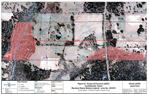
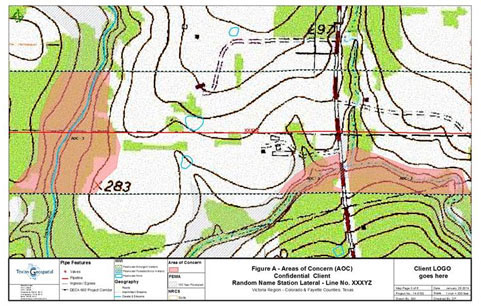
Mapping Areas of Concern
Asset Location and Inventory ultimately allow our customers to use the captured GPS data as a powerful tool in their corporate GIS toolbox for project and capital management. Whether older pipelines are being considered for commission back into service or construction of new pipelines are being planned for new production zones, knowing all you can about the pipeline corridor and the location of all potential Areas of Concern goes a long way in mitigating environmental risks and costly expenditures associated with oil spills and other damaging events.
With Texian Geospatial on your team it means you will have confidence in your data and map products. Our team of GIS, GPS and Environmental professionals excel at delivering maps and data that allow our customers to apply their best management practices and optimize their profit to loss ratio. All of our map products are reproducible and can be updated with new field data, external data and reset for alternate pipeline routes. In addition, each map feature can be updated as you integrate more information into your Database.
Quickly Incorporate Critical Asset Information from Remote Locations
Mobile Mapping Solutions
If mobile customization is needed, Texian Geospatial will develop a mobile solution that is cost efficient and reliable providing your Inspectors and Managers up to date inspection results. Using tablets, mobile phones, or other field technology, we are able to provide inspectors the information they need in the field. Customer need drives our development process from concept to implementation. Please email info@TexianGeospatial.com for more information or to meet and discuss your needs.